I have found this component to solve my Excel Reader browse issue, so I can integrate the reader into my component, instead of keeping it outside. Only the OAuth Node is the odd one out at the moment ![]()
Hi @badger101 ,
I had a quick stab at the “flow variable support”. While adding support to properly supply the values at configuration time (i.e. service, api key, secret, and scope), I’m not too sure if this will be sufficient for your scenario – at the end, the user will need to click the “Authorize Access” button to run through the flow, innit? Would this be possible when wrapping the OAuth node into a meta node at all? (I’m no expert in that field).
Any feedback or clarification welcome ![]()
-Philipp
Hi @qqilihq , you’re right on that matter. Due to the Authorize button, the OAuth node still needs to be left outside. I guess it’s okay then ![]() I wish I could give some pointers from the technical side of things, but sadly I’m not a coder.
I wish I could give some pointers from the technical side of things, but sadly I’m not a coder.
An option might be to start the authentication flow when executing the node, but I’m not sure I like this flow UX wise. I will see if we can come up with a better solution to that, but leaving the node outside of metanodes is my suggestion for now ![]()
1 Like
Thank you @qqilihq , I have learned that I didn’t need the OAuth node if the users key in their access tokens manually. I was able to use Twitter’s V2 API via the Palladian HTTP Retriever as long as I provide all the necessary tokens including bearer.
I’m just hoping there’ll be an update someday for the Palladian’s Map Viewer’s image output port as mentioned earlier ![]()
I’m sure there will be good news with an upcoming update. (not the 2.8 which we pushed today and about which I hadn’t even time yet to write about … well, tomorrow then).
1 Like
+++++++  Palladian Nodes 2.7 is available
  +++++++
Here’s a brief overview of the new functionality:
- A bunch of new geocoding nodes: GeoNames Geocoder, OpenCage Geocoder, and – powered by Palladian’s state-of-the-art geoextraction algorithms – the Main Location Extractor. The latter one is perfect for geocoding on a city/unit level and it can be combined with the Local Location Source and thus allows you to run your geocoding entirely locally without having to access any external APIs
- Geohash nodes to convert coordinate parts to geohashes and back:
- An improved ML model for the Location Extractor node
The full changelog is available here: Palladian — NodePit (and did you actually know that you can also subscribe to all changelogs on NodePit via RSS? Here’s the link: Changelog: All Products)
Enjoy!
–Philipp
5 Likes
@badger101 We have something to test – would you be willing to give the upcoming release a try?
![]() → mail@palladian.ai
→ mail@palladian.ai
–Philipp
1 Like
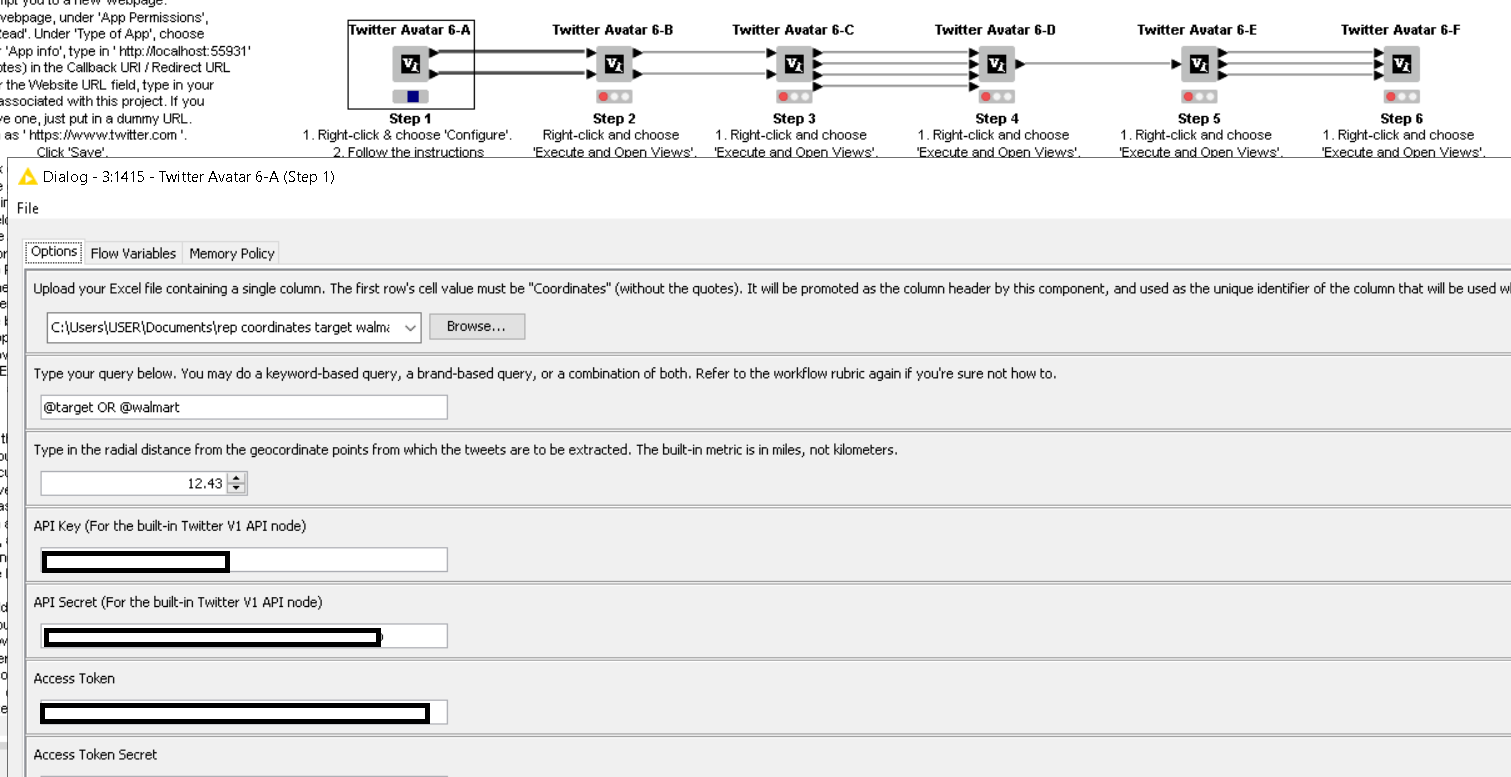
Update: Thanks @qqilihq for the trial/test version you emailed. For the OAuth, I can see that that variables can now takeover the fields.
As for the Map Viewer, I did a comprehensive test and here’s what I found:
- It works as you described in the email. That’s a good start!
- Here’s a screenshot of the result:

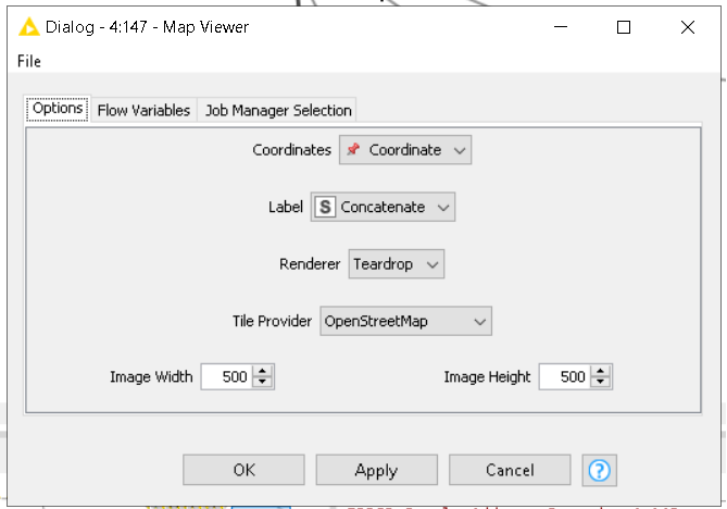
- If you have more time in the future, maybe you could take a look at why the labels did not appear on the map. Here’s how I configured the node to show that I have assigned the label column appropriately:
Here’s an image to show you the importance of the labeling for the case where the geographical region covered is very wide:
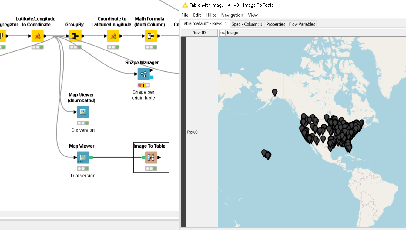
As you can see, for wide coverage, annotations would definitely help the users make sense of the map if the location names are seen. If you can also go further than that, for a dense map as shown here, it would make sense for the coordinates to be of different colors according to pre-assigned categories, with smaller teardrop sizes, and for the location names (label) to appear as map legends to avoid overcrowding of labels. But that’s just my opinion ![]()
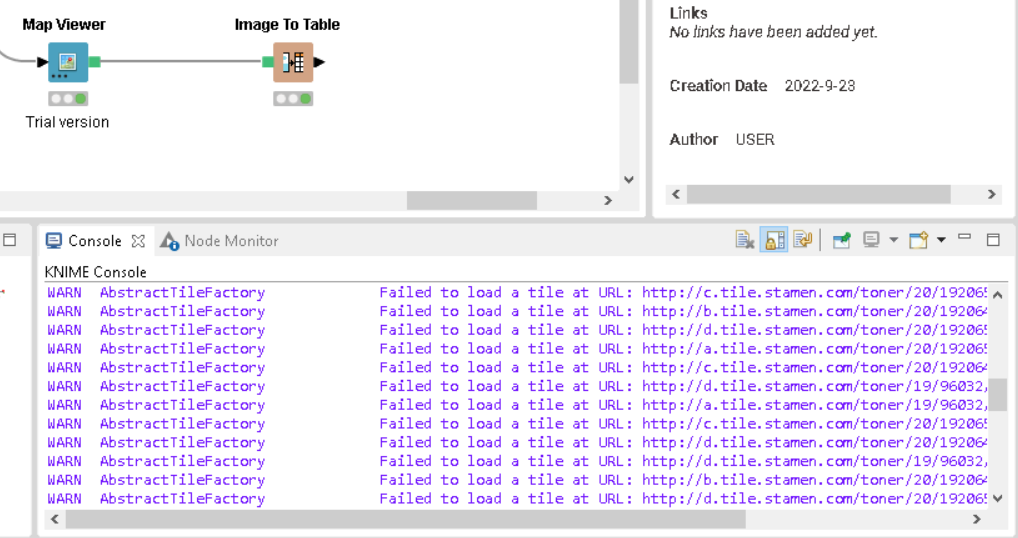
- As for the Tile Provider, I prefer the OSM as shown above. It works okay. But some of the other providers either gave me errors, or a non-workable image:
Here’s for Stamen:
Here’s for Apple:

But I don’t personally use these two tile providers, since the OSM tile alternative works for me and is my preferred option.
All in all, thanks for the work in this! Really appreciate it. ![]()
2 Likes
- For the labels to show, you’ll need to use the Labels renderer
- You can also assign colors and apply different sizes (for the “Teardrop” and “Circle” style) to the labels
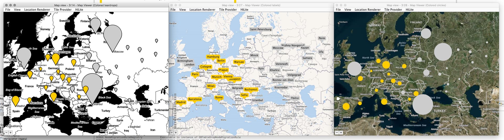
This can be achieved by putting size and color manager nodes before the Map Viewer:
As I think that these are probably less-obvious functionalities, I’ve put together an example workflow which will scrape a list of of European cities from a Wikipedia table and visualize these as shown above. I’ve shared it on my NodePit Space:
Hope this helps!
3 Likes
Oh wow I’ll definitely look into this tomorrow! At first glance that looks awesome!
1 Like
@qqilihq Thank you, I tried it on a dummy component and it works!
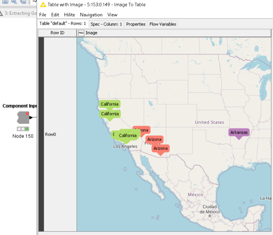
Hope to see it in the next official release ! ![]()
P.S. Is there a way to convert coordinates to their respective states/region automatically without prior info? (Kinda the reverse function of the Palladian geocoder nodes)
1 Like
Currently not yet (easily), but it’s in fact already a todo on our agenda ![]()
2 Likes
Alrighty, good to know! ![]()
Hi @badger101
You may have a look at the following workflow:
which is using on top of the Palladian geocoder nodes, a “street to GPS location dictionary” file called “allCountries.txt” that can be downloaded from GeoNames as a zipped file.
One may use this dictionary in the two senses (coordinates to street and the other way round). Although it is far from being the perfect solution because it doesn’t contain all the streets of the world, it may let you start implementing your own workflow based on this file while waiting for the future Palladian geocoder plugin release including this feature. You might implement from it a workflow that looks for the nearest GPS coordinates in the dictionary and returns the state/region as desired.
Hope it helps ![]()
Best
Ael
1 Like
Thanks @aworker , I’ll have a go at using the RLL node in a few hours. It sounds like it’ll do the job. Do you think it covers worldwide?
1 Like
My pleasure @badger101. The GeoNames dictionary is global with more than 12 million addresses from all over the world, although I cannot say how much that really covers worldwide.
Palladian 2.8 for KNIME is available
Changes in a nutshell:
- OAuth Connector (Custom OAuth 2.0): New node for OAuth 2.0 flows for arbitrary services
-
OAuth Connector: Flow variable support (see here)
-
Made plenty of existing nodes “streamable” (see e.g. here)
-
Regex Extractor: Template for hashtag extraction
-
Regex Extractor: Improved template for URL extraction (see here)
-
Compatible with KNIME 5 nightly, requires KNIME 4.5 minimum
The full changelog is available on NodePit here: Palladian Changelog
Update Site URLs:
- KNIME 4.7:
https://download.nodepit.com/4.7 - KNIME 4.6:
https://download.nodepit.com/4.6 - KNIME 4.5:
https://download.nodepit.com/4.5
5 Likes
This topic was automatically closed 90 days after the last reply. New replies are no longer allowed.