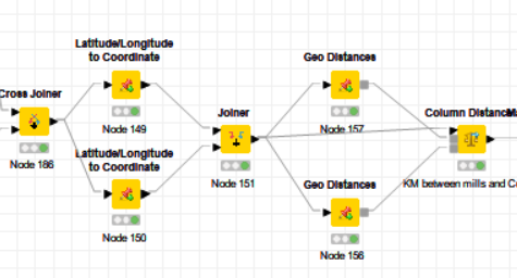
I have created the following model to compute the aerial (or point to point) distance between two geographic points given the zip code or specific addresses.
I am wondering if there is any way to find the travel distance between the two points using Google Map, Map Quest, Waze or similar applications.
Thanks in advance,
Zane
If you don’t mind using other sources than your mentioned commercial ones OpenStreetMap https://www.openstreetmap.org (OSM) might be source to use.
The data in OSM - with respect to the license - is freely available and there exist several APIs to calculate e.g. routes. Have a look on https://wiki.openstreetmap.org/wiki/Routing to get an overview on routing and available APIs.
@knimediger,
Thank you for your reply. I am looking into it and most likely I will use the Python option. Should I use a Python node? Any hint or advice is appreciated.