Hi! I have a dataset of 1,000 addresses and their corresponding lat/long points. I have run the addresses through two different geocoders and received new coordinates from both. I am trying to measure the distance between my original coordinates and the ones provided by each geocoder. I have broken the data out into two files, which each contain the address ID #, original points, and the results from one of the geocoders.
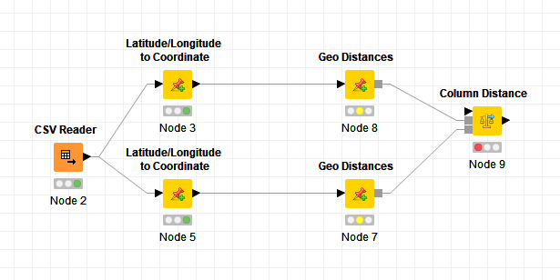
I have gotten as far as reading the first CSV file, converting the lat/long points to coordinates using two Latitude/Longitude to Coordinate nodes, then using two geodistance nodes and sending them to the Column Distance node, but when I try to attach my original data set from CSV Reader I receive an error. Would anyone be able to tell me what I’m doing wrong/point me in the right direction?
Thank you!
Hi there,
@danielesser wrote a short, nice explanation how to use it here:
You can get the example workflow from his NodePit Space here: calculate-distance-between-two-latitude-longitude-points-11152 — NodePit
Does this help?
– Philipp
5 Likes
@kayserroll Did it work?
Very helpful - got it working this morning! Thank you so much.
2 Likes
Superb! Thanks for the feedback!
This topic was automatically closed 90 days after the last reply. New replies are no longer allowed.