Continuing the discussion from Python output to a dataframe:
geospatial extension ,i want to know which time we can use geospatial extension, thanks.
Hello @GISer_last ,
we are working together with the Center for Geographic Analysis at Harvard University to develop a geospatial extension for KNIME. A preview of the nodes will be available with the December release.
We will talk about the collaboration and demo the extension at the KNIME Fall Summit in Austin.
Would you be willing to share with us your use cases and where you get the geospatial data from e.g. files (coordinate file, shape file etc.) or databases (PostGIS, Snowflake, etc.)? This would help us to improve the extension.
Bye
Tobias
6 Likes
hello @tobias.koetter , now I like knime very much ,Please forgive my English,Recently, I have been using it to help me complete the data acquisition. Limited by its limitations in gis spatial analysis, I now learn geopandas to handle it, but it is not efficient.I’m really glad to thank you for your reply. I look forward to using the geospatial extension as soon as possible, so that I can provide the current efficiency.The following picture is my test case. After using knit, I can’t put it down. We look forward to more communication with you later. I have also contacted the Geographic Analysis Center of Harvard University, but I cannot install it at present. I would also like to have the opportunity to share some of my cases and experience in the future, especially in geospatial analysis, which is my interest. thanks.
Hi!
In terms of GIS, my needs are basically: geocode addresses (Im using Geopy for that), transform Lat and Lon to POINTS, and write it into PostGIS.
@tobias.koetter Hello, I have tried to use KNIME, combined with echarts (an open source js platform for making various visualizations, similar to Google api js), to successfully implement KNIME+Echarts. Later, I can use this as a basis and extend it wirelessly according to this idea, for example,
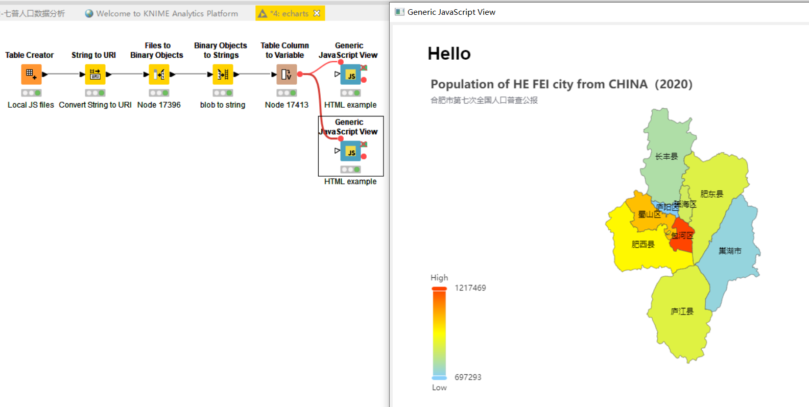
to analyze the seven population censuses in China, and so on. However, the current difficulties, or how to better integrate gis data.
1 Like
Hello everyone,
I’m happy to announce the release of the Geospatial Extension for KNIME: Geospatial Analytics Extension for KNIME – KNIME Community Hub
we will continue to add more functionality to it and are looking forward to your feedback.
Bye
Tobias
6 Likes
Can I confirm that, at the moment, KNIME can only handle one geospatial layer at a time. What I am seeing is that I can read one layer out of a GeoPackage at a time, and display one layer at a time.
But I cannot take all the layers from the Ordnance Survey (OS) Open Zoomstack product (here), which has 21 layers; add a theme to the OS data with custom symbology for railway stations, airports etc; add a few more layers of my own data with custom symbols and display the resultant output in a viewport.
I can understand if my ambition exceeds current capability, but just want to make sure that I am not missing something obvious. ![]()
DiaAzul
Hello @DiaAzul ,
you extract different layers into different KNIME tables by using multiple GeoPackage Reader nodes with different layer names. Once you have the tables you can independently work on them. Once you want to work on all layers in the same way or you want to plot the layers together in a Geospatial View you can concatenate the table to create a single table. This table can then be fed into any of the Geospatial View nodes.
Please notice that the Geospatial View nodes draw the geometric shapes in the order of the input table. Meaning that the first input rows are drawn first and the last rows are drawn last. So anything that should be drawn in the background e.g. areas should appear first and anything that should be drawn in the front e.g. points should appear last in the input table.
Bye
Tobias
2 Likes
@tobias.koetter Hello, how can I find your personal contact information and reflect the application of geospatial node library to you.It is better to communicate directly through voice, although my English level is not good.We Chinese people use WeChat most.Is it convenient to not know? If it is inconvenient, I will delete this message in time. Excuse me.
Hello @GISer_last ,
would love to talk about your use cases. I send you a private message with connection details.
Bye
Tobias
1 Like
This topic was automatically closed 90 days after the last reply. New replies are no longer allowed.