Hi all,
I currently use QGIS to run a query and identify the City names for all the coordinate points I have in a CSV file, however, since I found out Knime now supports geospatial analysis I was trying to build a workflow where I would import an SHP or KML file with the polygons, and a CSV file with the coordinates. Then the idea is to create an output file with all the coordinates and the associated city names.
This is probably simple but I am having a hard time making it work using either “Geospatial Analytics” and/or the “Spatial Processing” community nodes.
Would anyone know how to proceed?
Thank you all!!!
1 Like
Hi @mauronareba welcome to the KNIME Forum!
Would it be possible to share with us a tentative workflow with some dummy data? This would help in understanding your issue.
In the meantime, if you want to master the Geospatial Analytics nodes, here are a few resources you might be interested in
- KNIME Geospatial Analytics Extension (Youtube Playlist)
- Using KNIME Geospatial Nodes to Graph Earthquakes (YouTube video)
- Geospatial Analytics Examples (KNIME Hub Space with example workflows)
Cheers,
Emilio
1 Like
Hi Emilio,
Thank you for the resources you shared. They helped a lot.
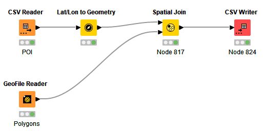
I was able to build the following flow and it worked!!!
As I could not make the KML work, I needed to take an extra step to convert the KML file to SHP so it could be imported into the GeoFile Reader node.
Please let me know if you know a more elegant way to use the KML file straight without the need to convert it to SHP first.
Thank you
Cheers
Hello @mauronareba ,
I have created a ticket for supporting KML files in the GeoFile Reader in the Geospatial repository. However it seems that the parser has some limitations e.g. the nested nature of folders in a source KML file is lost. I hope this will not be a problem in your case.
We are also working right now on a Reverse geocoding node that will allow you to extract the address of a given geometric point.
Bye
Tobias
3 Likes
This topic was automatically closed 90 days after the last reply. New replies are no longer allowed.