hello
I have an Excel file containing some geographic coordinates that I want to display offline on a map
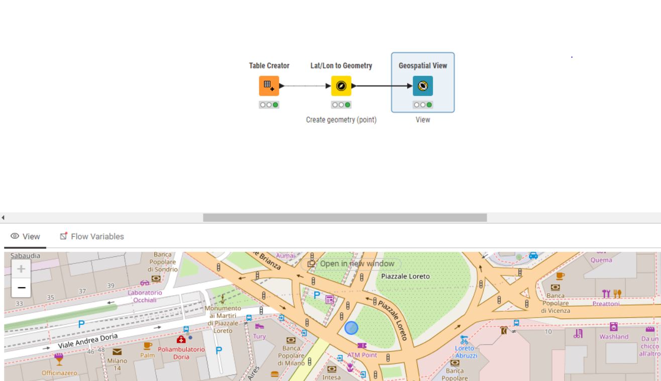
I use lat/lon to geometry and geospatial view nodes, but I need to connect to the Internet to display the geographic coordinates, but I want to see the coordinates on the map without using the Internet.
please help me
Hello @alex1368,
I believe the only way to do this will be a bit involved as you will probably need to use python script.
So, essentially the idea would be to have a local image of a map, and then you can try and overlay the geographic points on this image, which should get to the solution you want.
You will need to first download an image of the map that spans the coordinates you have, but you will need to store somewhere (or just write down) the actual bounds of the image (ie. like how it corresponds in lat and long). In the python script it will probably look something like this:
minimum_lat = ...
maximum_lat = ...
minimum_long = ...
maximum_long = ...
Now the tricky part is converting these coordinates to pixels as we have to work with the image, but it looks like you may not need to do that if you use the libraries geopandas along with matplotlib.
Hopefully this gives you some pointers on how to start!
TL
2 Likes
Is it possible to display the world map offline?
I want to display some geographic points on the map offline
Sorry for posing questions first before giving answers.
What do you mean with offline? A computer without any network / connection?
Just offline from KNIME?
Or no connection to a map server?
What about interaction? Shall it be possible to navigate in the map, zoom in and out?
A first idea for a fully offline map would be to create a graphic of your map which will be used.
That would be a fully offline version. But nearly any possibility for interaction.
Hello, thank you for your attention to my question
1- What I mean by offline is that my computer and server do not have access to any internet network and operate as a single.
2- My knime is also offline, but I have full access to my server and system
3- I want to zoom in and zoom out on the map
4- My requirement is exactly a completely offline map so that I can display the coordinates on the offline map through knime geography nodes.
Which map do you want to use - Choropleth or Geospatial Extension? You’ve asked the same question in two other posts. Help keep the Forum clean by not reposting the same question multiple times.
1 Like
I am currently online using the nodes mentioned in the picture below, but my problem is in offline mode.
My requirement is the same as the picture below with the feature to get the answer I want offline
Sorry for asking the question! I have a very big challenge about this and I need to solve it
Merged two of them. Just bump your old topic next time, there was even a reply from a staff member ![]()
1 Like
I did not find the answer you said, please reply for me.
Of course, the available answers are only for the online mode and have access to the Internet, and they do not exist in the mode without the Internet
The Geospatial extension uses OpenStreet Maps (OSM) by default for rendering which requires an internet connection. I don’t think there’s anything in KNIME or its extensions which gets around this. I’m certainly not an expert in this area. See if this gives you some ideas:
https://wiki.openstreetmap.org/wiki/Using_OpenStreetMap_offline#:~:text=Many%20software%20tools%20and%20services,a%20basement%20or%20subway%20(metro)
Could you share your workflow? I have something I’d like to try.
3 Likes
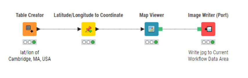
If you can live with a static offline map this will work. It would be a lot easier to help if you’d share your current workflow.
Offline Map.knwf (524.0 KB)
1 Like
Thank you for your answer, but this workflow must be online and it does not work offline
With your strict definition of the “offline restriction” you might need to think about some realistic solutions.
Offline means first of all: No connection to any existing tile server like OpenStreetMap, Bing or others. So a tile server is the first part you need to provide by yourself on the offline PC or somewhere in the available network.
Using OpenStreetMap it would possible to host such a tile server.
Using redirection might allow you to point to your tile server instead of OSM.
The next point still not clear to me is the user story: What exactly are the user stories? How will the user work with the frontend? Is a full map navigation required or can it be restricted to e.g. some zoom states with the given coordinates? Shall KNIME work as frontend? Do you have any app as frontend?
Along with the other spare information it is quite complicated to give you precise hints and ideas.
Perhaps it would possible to provide more information and details about your requirements, user stories, network possibilities, …
That would enable the community to give more precise hints.
3 Likes
My friend, let me explain the exact problem
1- I have a computer system that is not connected to any network and works single.
2- Internet is not connected to this computer.
3- My requirement is to see a series of geographic coordinates in the form of lat and long on the map.
4- I have admin access to my computer system
5- I can save the series of prerequisites needed to view a coordinate on the map on my computer (if needed).
6- The map in my mind is only a specific country and I don’t need other countries
I emphasize that I do not have access to the Internet.
You stated:
3- My requirement is to see a series of geographic coordinates in the form of lat and long on the map.
Where do expect the map to come from if you have no internet connection to create or download one?
3 Likes
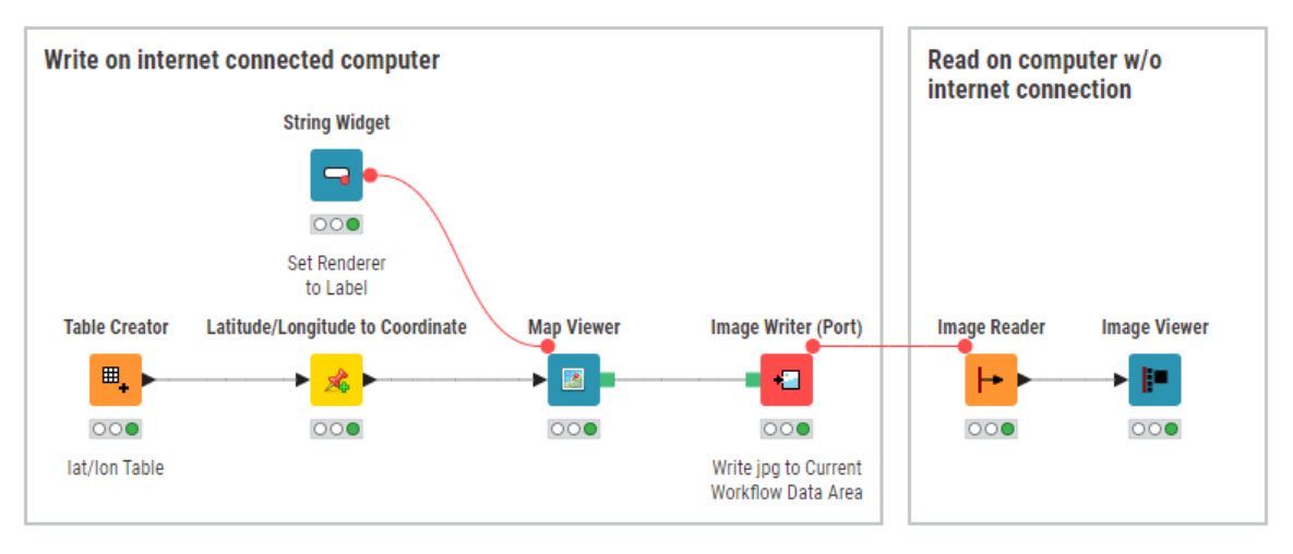
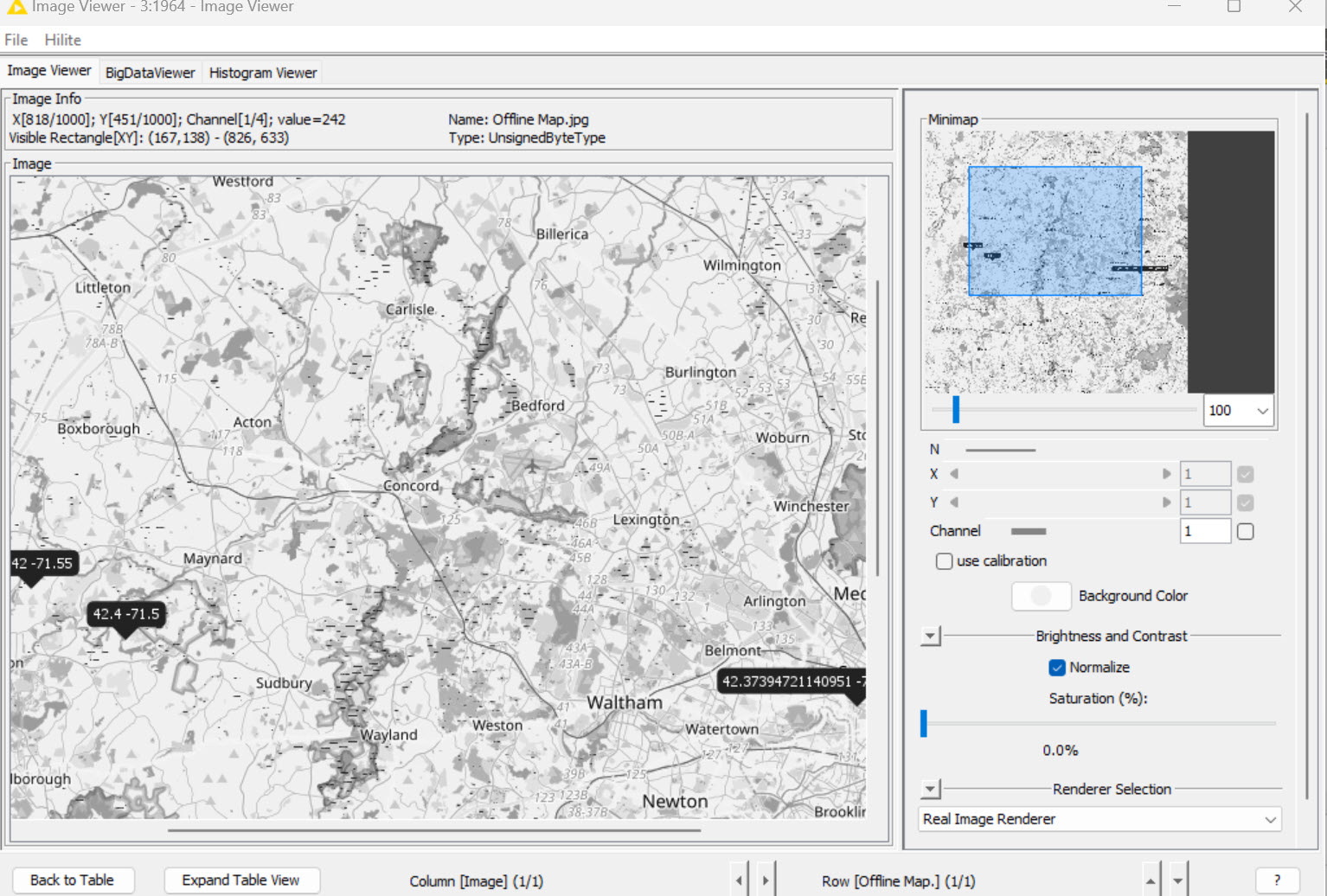
If you have access to a computer with internet access you can create the map there and then read it on a computer without internet access. Here’s a workflow with a rudimentary approach that works. Split the workflow as shown by the boxes. If this won’t work for you I think you’ll need to find another platform than KNIME or someone a lot smarter than me.
Offline Map.knwf (1.9 MB)
1 Like
I also stated in the text above that I can download a map from another place and transfer it to my computer that is not connected to the Internet
I don’t know what the problem is
How are going to overlay coordinates on on a flat map?
You see, I display the coordinates on the map in the online system connected to the Internet through the Display geographic “coordinates on the map inside knime” node.
Even now, my problem is calling the map in this workflow
If I can download the map and load it in the desired workflow path (if I find the path and can download the map), I can use the desired workflow easily.