The KNIME Geospatial Analytics Tool is ready for use. You can use this tool to process GIS data. However, this tool is at an early stage and needs to be further improved with the update of the version. If you are interested, you can try. I look forward to sharing the operation of this tool with you. thank you.

8 Likes
Where can I find this?
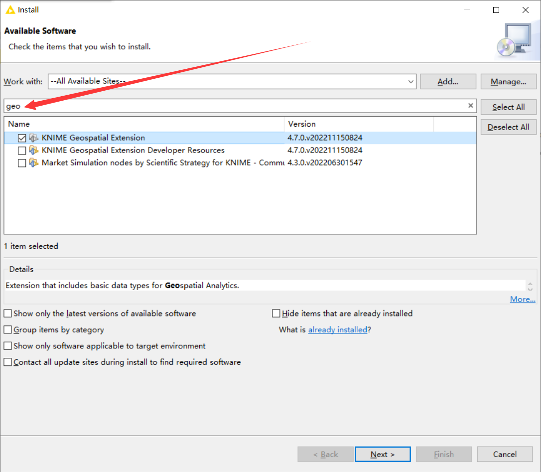
@rfeigel hello, knime-geospatial-extension is beautiful,please download it and enjoy it.
This repository is built for KNIME-CGA Geospatial Project, and the goal is to build Python-based nodes for geospatial analysis in KNIME Analytic Platform.
Tips: knime 4.7 nightly build . and Anaconda, python environment
Good luck.
3 Likes
Hi @GISer_last , does the Extension require Python environment?
@badger101
hello, yes,it is. This txtension is developed in Python, so the Python environment is required.
I see, thanks for the info!
The extension isn’t available for Knime 4.6.3?
hello, you can read my last reply, tips: knime 4.7 nightly build . and Anaconda, python environment.
Hi @GISer_last
I would like to know if your knime-geospatial-extension is capable of creating latitude/longitude (2d) values for each distinct geometry column values (3d) read from a shapefile ?
For the moment, as a workaround solution i’m following detailed explanations steps present in below url using QGIS software but i would prefer to perform it directly from a knime workflow
Many thanks for your reply
Kind Regards
1 Like
Hi @stephboi
First, The Knime-Geospatial-Extension is KNIME Team with the Center for Geographic Analysis at Harvard University to develop a geospatial extension for KNIME. Not mine.
Second, Knime node can do your problem. you can see Convert a WKT Polygon string to Geometry - #2 by marvin.kickuth. If it can’t be solved, send the data to me, and I will make a workflow for you.
Third,The Knime-Geospatial-Extension can do this ,but Slightly slow,Because it may be due to the version, it should be OK when the knime is updated to 4.7. you can try it.
Good Luck!
I think there is a misunderstanding about my initial plea.
I perfectly know how to use any dedicated knime node from any given Knime extensions allowing to read any shape files package including .shp file extension + other packaged files (.dbf, .prj, .shx files) and extract from this shape file the dedicated geometry column which is a 3d representation allowing to draw a polygon of each distinct areas present inside this geometry column.
My initial question was is there amoung this Knime-Geospatial-Extension any calculation node allowing to reproduce what i have done manually using QGIS software
to know :
- Open any .shp file from QGIS software
- Select layer in layer list and Open Field Calculator (abacus icon in top menu). Or Right click on layer / Open attribute Table to see all columns and click on abacus icon in top menu of table window.
- Select if you want to create new field or update existing (if you use existing field make sure the field type is number type with 6 decimals)
- Type as expression for longitude : x(centroid($geometry)), and for latitude y(centroid($geometry))
- Once you have both latitude and longitude fields expressed into 2 dimension (flat) values export these 2 table attributes into csv. In my case it would rather be add these 2 columns into my workflow pipeline combined with geometry column retrieved from shape file reader node)
Finally i’ve got my answer by watching a video demo of Knime Geospatial Analytics extension published on Knime website.
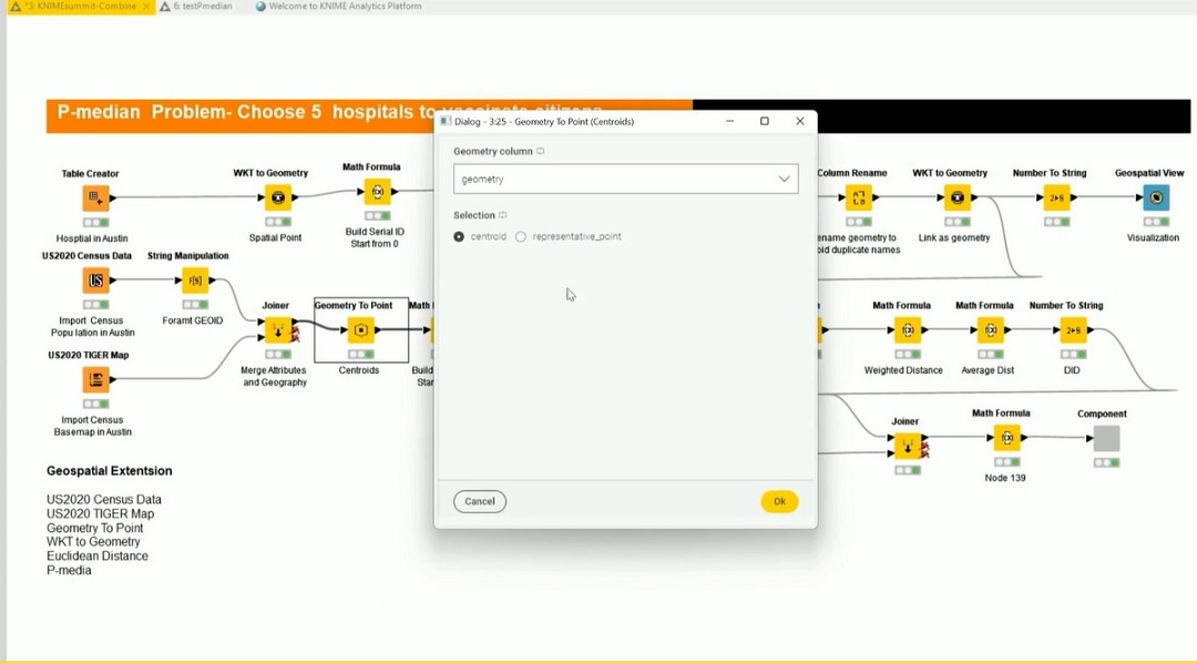
In user case 2 they demonstrate in a Knime workflow usage of Geometry to Point node which performs exactly what i was expecting (see attached screenshot below)
2 Likes
Apologize to you! I have been too busy recently. Please forgive me for not replying in time. Congratulations, as you wish. Just use it. I guess he can help you do what you want.
Best Regards!
I searched in the install software function and can’t find the extension.
Geospatial Analysis
What’s New in KNIME Analytics Platform 4.7 | KNIME
This new Geospatial Extension provides the ability to carry out geospatial analysis within KNIME. In its first version, it will support the most common vector data types such as points, lines, polygons, and collections of those. It is a joint development by the Center for Geographic Analysis from Harvard and KNIME bringing together top geospatial and KNIME development expertise. It is a trusted community contribution and we will continue to improve it further.
With KNIME AP 4.7 the new Python integration is now ready for your production environments. Its most notable improvements are much faster data transfers between KNIME and Python, a better Python API, and a bundled Python environment to get you started without having to install Python yourself.
In terms of scripting functionality, this release brings:
- Enhanced script API and type support especially for date and time formats and chemical types
- Improved RowID handling and RDKit support for molecules, fingerprints, and reactions
- Shipping of more recent versions of Pandas, PyArrow, scikit-learn and the addition of OpenPyxl
- Simplified custom Conda environment creation, Conda packages available at knime :: Anaconda.org
- Support for native M1 Mac Python builds
Please note that the previous “KNIME Python Integration” is now called “KNIME Python 2 Integration (legacy)” and should from now on only be used if Python 2.7 support is required. Similarly, “KNIME Python Integration (Labs)” now changes to “KNIME Python Integration” and loses the “Labs” suffix, same goes for the nodes and preference pages. See updated documentation here and here.
3 Likes
Even thought the extension is written in Python you don’t need to bother with it. KNIME Analytics Platform takes care of all dependencies. So you can install and use the extension as any other extension in KNIME ![]()
2 Likes
Hello @rfeigel
please ensure to update to or install KNIME Analytics Platform 4.7.
Once installed or updated open KNIME and simply drag and drop the Geospatial Analytics Extension for KNIME from the KNIME Hub:
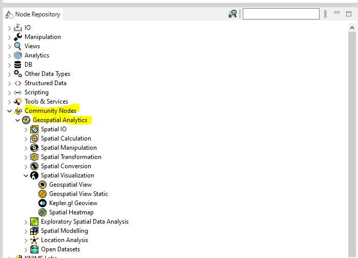
Just follow the instructions and KNIME Analytics Platform will download and install the extension with everything that is required. Once you have restarted KNIME you should find the Geospatial nodes in Community Nodes->Geospatial Analytics
We also provide some example workflows to get you started and we will continue to add more. They are available in the KNIME Hub on the page of the Center for Geographic Analysis.
Let us know if you encounter any problems.
Bye
Tobias
1 Like
This topic was automatically closed 90 days after the last reply. New replies are no longer allowed.