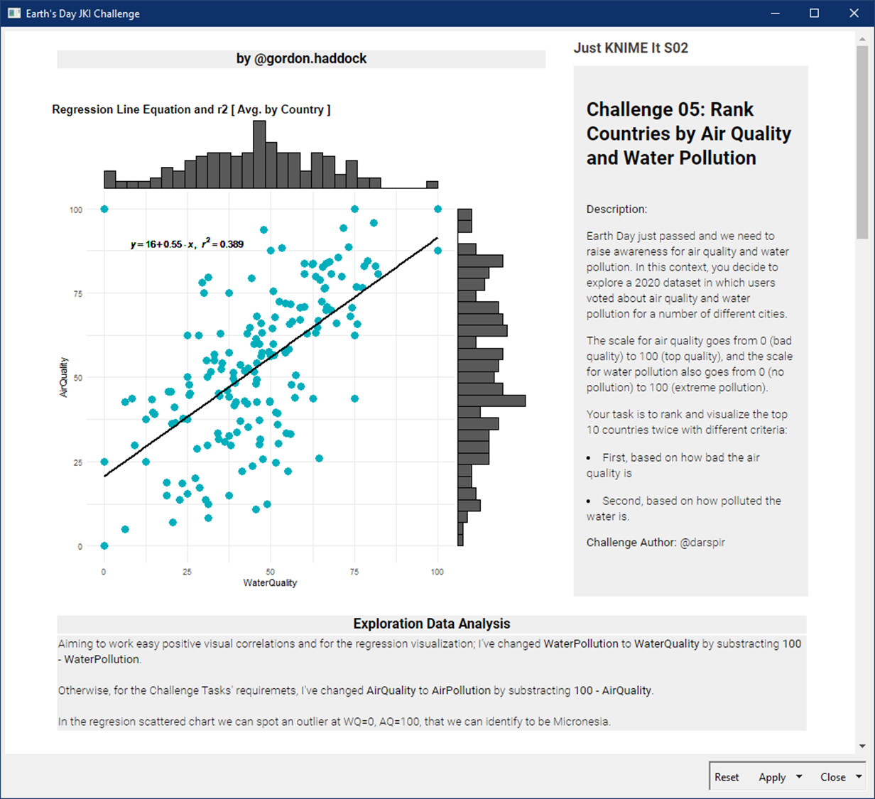
Solutions to "Just KNIME It!" Challenge 05 - Season 2

Hello Knimers,

here is my solution:

Few remarks on what I’ve done:

  • I replaced some country names in order to represent them:
    immagine
  • Talking about air quality and water pollution (0 can be either good or bad, depending on the fact you are talking about quality or pollution level), so i decided to convert water pollution into water quality
  • I introduced an overall score, that is a simple average between the two quality scores.

Have a nice day,
Raffaello
LinkedIn

3 Likes

Hello KNIMErs, Here is my Solutions for “Just KNIME It!” Challenge 05 – Season 2

3 Likes

My take on the challenge 5 -season 2. Bit raw


8 Likes

I computed the average score for each country in each category, then queried the long lat of each country and used this to display the most polluted country for air and water on a map.

JKISeason2-5 – KNIME Community Hub

6 Likes

Here’s my solution. Top and bottom 10 countries for both air and water. Also % of international mean. Added small value to any 0 score so country/average would compute.

1 Like

Hello KNIMErs
This is my take on JKI S02-CH05. The challenge is quite interesting; I could recycle my R visualizations from previous S01 Challenges, then I could concentrate on building the dashboard, adding value to the analytical part.

Running the Dashboard may require some R-packages that are not listed, sorry for that, I’ll try to update in workflow labels later.

Enjoy. BR

7 Likes

Here is #5, I deviate from requirement but just to give a nice overall summery view of the data.

2 Likes

My solution is quite simple.
Just used the mean o of the cities notes to attribute a note for the Country.
Then, created two separated ranks, filtered the top 10 rows and displayed them with Table View Node.

Nothing fancy like the guys usually do… :slight_smile:

1 Like

Here is my solution.
Only the Top 10 countries are shown on the Map.
Cote d’Ivoire must be converted to Ivory Coast or CI to appear on the Map.
The following three countries could not be displayed on the Map.
Federated States of Micronesia, Marshall Islands, Maldives

7 Likes

Here is my solution. Again, I believe it is good to wrap up the main part as a component.

2 Likes

Hi all, here is my solution.

2 Likes

hey all… ive never used the Geospacial or OSM nodes before so i was really excited to learn some ew things here. however, after updagrading to 4.7 so i could use them, i am getting this problem… i cant seem to find a solution. has anyone seen it before? thnak you in advance.


Also- i am sure this isnt the right place to ask about this, but since i knew there would be many people working with these nodes i here, i thought it was worth a try…

1 Like

This is my first time posting to Just KNIME it.
Sort buttons on the column header can be used to sort the countries by median/mean, showing top 10 countries.
The integer input window is for setting a lower limit of the number of cities.

5 Likes

Hey @l6fader, could you upload your workflow to your public space on KNIME Hub and link it here? I’d be happy to download it and try to reproduce this error on my machine and see if I can get a proper solution for it. Thanks!

Embarrassingly, this is the unmodified workflow (Task 3) from Rosaria, Roberto and Elisabeth’s blog on the topic:

when i drag/drop the WF into my freshly installed 4.7, this error is the result. :frowning:
i was wondering if the issue could be related to the fact that i have multiple installs of KNIME on my machine. but alas, i want to get this challenge done so i will work with another solution… and come back to the geospacial nodes soon.
thank you!

1 Like

Finally, here is my solution, right under the wire. Went with custom Plotly Chloropleth map since I have implemented this before.
The data app first displays two maps showing Air and Water quality as country averages:

Then you are able to filter by country to get a new map (maybe not so important) and a table with cities within that country and their global rankings.

This one was fun, but i look forward to figuring out the KNIME nodes for Geospatial stuff…
L

4 Likes

Hello people,

I were a lot busy, and I saw many did excellent solutions, I don’t know if the problem needs to implement graphical solutions, someones with maps, other only plots and other do not implement any visual features to enrich the result, I share some solutions for this easy challenge:

  1. In this JKISeason2-5 ver 1.0 – KNIME Community Hub flow, only use the simple segmentation using the mean over the records about the pollution in water and air, and count cities reported in each country
3 Likes


//

1 Like
  1. In this version: JKISeason2-5 ver 1.1 – KNIME Community Hub, not only show the 10 countries with pollution problems, here take in maid the 10 top highest or lowest pollution index and using this point, the final result increase the number of countries that report cities with pollution problems in water and air
1 Like
  1. In this flow: JKISeason2-5 ver 1.2 – KNIME Community Hub, show all the cities than have pollution on air or water.
1 Like